 EM-31
Conductivity & Hydrocarbon Contamination Detection
EM-31
Conductivity & Hydrocarbon Contamination Detection
The EM-31 uses a frequency domain electromagnetic technique to measure and map ground conductivity and magnetic susceptivity. It provides the capability of mapping subsurface features or contaminants that are associated with or produce changes in ground conductivity. This tool has many uses where ground conductivity changes are measured and may indicate buried pipelines, drums, Underground Storage Tanks (USTs), and subsurface contamination.
Applications
| • |
Mapping groundwater contaminants |
| • |
Detection of buried metallic structure (i.e., USTs, drums, pipelines and well-heads) |
| • |
Detection of buried waste materials |
| • |
Minerals exploration |
| • |
Environmental investigation |
| • |
Archaeological and forensic investigation |
|
|
Advantages
| • |
Fast, accurate and cost effective |
| • |
Exploration depth to 20 feet |
| • |
Ideal for geotechnical and environmental site characterization |
| • |
Allows measurement without electrodes or ground contact |
| • |
Conduct surveys under most geologic conditions (including high surface resistivity conditions – e.g., sand, gravel, and asphalt) |
|
 EM-61
Metal Detection Surveys
EM-61
Metal Detection Surveys
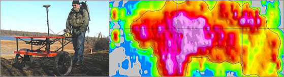
Time-domain electromagnetic metal detector that detects both ferrous and non-ferrous metals. The EM-61 provides high resolution, external noise rejection, and excellent depth of investigation making it the best choice for buried metal detection. It is used primarily for the detection of Underground Storage Tanks (USTs), drums, pipelines, and Unexploded Ordnance (UXO).
Applications
• UST detection
• Buried metallic object detection (e.g., drums and pipelines)
• Utility locating
• UXO detection
• Environmental investigation |
|
Advantages
• Fast and cost effective
• Detects ferrous and non-ferrous metal
• Improved location accuracy
• Improved discrimination of multiple targets
• Insensitive to nearby cultural interference, such as fences, buildings and power lines
• Greater geophysical anomaly characterization when integrated with magnetometer data sets |
|
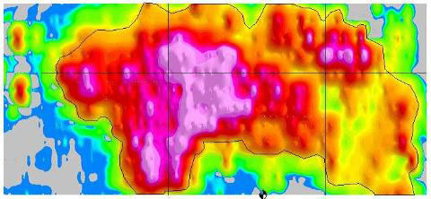
This is a color contour display generated by the Geosoft OASIS montaj™ software package and is used to identify anomalies associated with multiple buried drums in a landfill. ( Click to enlarge) |
|